Historical Diagram of Copperfield - Area Sites
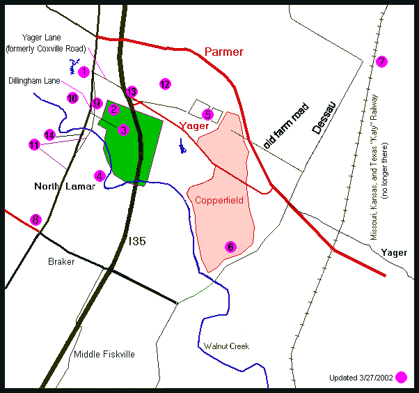
Interpreting this map
The Copperfield neighborhood is at the center of this map. The numbered pink circles on the map indicate points of interest from various time periods. The items in black and green were present in 1954. The items in red are more recent items. Interstate 35 was just built in 1954. The large green area is Dillingham Pasture.
A farm road was located north of today's Yager Lane and crossed through what is now the north part of Copperfield. The exact location of the farm road seems to be a little north of Markham on the west end and it passes through (today's) Captain Hopkins Cove and crosses (today's) Parmer Lane just beyond the north end of Thompkins.
Index of Numbered Items
1. The Coxville Zoo 1939-1970. The blue object nearby is a former lake that belonged to the zoo. Photos added, 9/7/01
2. The Bullhead Inn 1925 (approx) - 1935 (approx)
3. Dillingham Pasture. 1925 (approx.) - 1940. The green-shaded area is a rough approximation of where Dillingham Pasture was. The small line inside the green is Dillingham road. See reference at Early Residents -- Dillingham Pasture
4. Stark's Mine (a man-made cave). See reference at Archaeological Remains in Copperfield / Northeast Austin
5. A Nearby Dairy Farm, owned by the Doering Family. 1920s. (See Early Residents)
6. Angus Valley Ranch. Up to 1960 (approx.). (See Early Residents)
7. Dessau Hall. (See Dessau, Texas)
8. The Skyline Club. (See
A History of North Lamar Boulevard )
Sketch added, 2/27/02
9. The Owl Club/Country Music Museum/Auction House. (See information and photos at
A History of North Lamar Boulevard )
10. Indian artifacts and early homestead remains at Walnut Creek park. (See Walnut Creek Archeology)
11. North Lamar and old Highway 81. (See photos and text at
A History of North Lamar Boulevard )
12. Fox/Kellam house. (See reference to Luther Fox at Archaeological Remains in Copperfield / Northeast Austin)
13. Former site of a small dam and water pond on the creek, sometimes used for baptisms.
14. Location of a spring used by several area residents until about 1957. The spring always held water and was walled in by bricks. The water surface was said to be six-to-eight feet wide. The exact location has not been found. (Leon Carter, personal communication, 4/20/01) Added 3/27/2002
Return to Copperfield History Page

FastCounter by bCentral