Walnut Creek District Park: Archeological Testing At The Wells Site 41TV368
The information on this page comes from a document published in 1981 and placed at the Austin History Center titled “Walnut Creek District Park: Archeological Testing At The Wells Site 41TV368 (Call # 976.431 Ly).
This report is a treasure trove for anyone interested in northeast Austin history. The document provides an interesting historical overview of the area in and near Walnut Creek Park in north Austin. It mentions the discovery of various Native American artifacts. There are also some descriptions and photos of homesteads built on the land. Some of them are gone; others were still evident and were photographed for this report. This web site displays some, but certainly not all, of the interesting text and sketches contained in the document.
****************************************************************************************************
ABSTRACT
Archeological testing of the Wells Site 41TV368 documented thinly scattered Archaic remains in areas of impact with deep soils and possibly buried remains outside the impact area. A minimum of scientifically significant data will be lost due to construction. Historical research revealed potentially important data may exist at the Cearley Home Place 41TV379 and at the Ross' Spring House 41TV370. Site 41TV370 also exhibits well preserved prehistoric remains in certain portions of the site.
Page ii
HISTORICAL BACKGROUND
Although the Spanish were the first Europeans to enter Central Texas, and were undoubtedly familiar with the Walnut Creek area, they established no known permanent settlements in the vicinity. By the time American colonists reached what is now present-day Travis County in the 1820's, the only inhabitants they encountered were wandering groups of hunter-gatherers usually referred to as Tonkawas. These loosely organized, numerically weak bands exploited the wild game and plant foods found along Central Texas rivers and streams such as Walnut Creek, with only occasional. attempts at rudimentary agriculture. Unable to seriously challenge other tribes, such as the Comanche, Kiowa, and Lipan Apaches, for control of the buffalo-rich plains to the north and west, the Tonkawas quickly allied themselves with the early Texans for protection against their more powerful neighbors. During the Indian conflicts of the nineteenth century, Tonkawas often served as scouts for the Texas Rangers and United States Army (Newcomb, 1961:133- 153).
Two of the former landowners in the present park area, Ada Cearley and her brother-in-law Fred Cearley, recall tales that a group of Tonkawas were once maintained by the Army during the early 1850's on the south side of Walnut Creek near where the present high power lines cross it. "They used them to scout against the Comanches and other tribes, while they figured out some place to put 'em,"(Ada Cearley 1980:personal communication). If such an encampment did exist (no archeological or archival evidence has yet been found to confirm the story), the arrangement was undoubtedly terminated with the establishment of the Brazos Reservation further to the northwest by the Texas Legislature in 1854.
Local folklore also suggests that a man named Ross built a house during the 1840's on the north bluff of Walnut Creek above a spring which several old-timers still refer to as "Ross' Spring." The structure later was reportedly used as a school house. Although a tiny seep still trickles in the north bank of the creek, a survey of the area revealed only a thin scattering of 19th century ceramic sherds and bottle glass. The name Ross, does not appear on any of the early maps of the vicinity and no definitive evidence of a house site was discovered.
Somewhat further to the west, Fred Cearley (1980:personal communication) remembers stories of a Texas Ranger encampment and horse race track in the area. Here again, a surface search of the location produced no evidence to support the tale and no confirmation of such activities in the vicinity has been found in the historical records.
Help us find information on this item.
Archival research however, did reveal numerous references to incidents occurring in the general Walnut Creek area. Somewhat to the southeast of the proposed park area, the first recorded instance of Indian conflict in Travis County was the attack upon a hunting party of settlers at Walnut Creek in August of 1833. In this well publicized affair, two white men were killed, while one, Josiah Wilbarger, was scalped and left for dead. He survived this traumatic experience to live an additional nine years, thereafter wearing an old sock over his exposed skull as a reminder of his narrow escape (Black, Keever, and Morehead 1978:24). Somewhat later, in the summer of 1841, Lamar's ill-fated "Santa Fe Pioneers" camped some nine miles north of Austin on Walnut Creek prior to setting out for New Mexico. One unlucky member of the expedition, Andrew J. Davis, was killed by the accidental discharge of his own gun, an incident sadly noted by the Austin City Gazette (June 16, 1841) and Texas Sentinel (June 17, 1-9-41). According to informant Fred Cearley, who recalled hearing stories of the event, his body was buried just to the west of the present District Park.
Two years later, Walnut Creek was also the locale of the so- called "Archive War" of 1843. This bloodless encounter occurred when President Houston attempted to remove the land office records of the young Republic from Austin to Houston. His agents were overtaken by outraged citizens at Walnut Creek and the archives returned to Austin, an event of no small consequence to that city's perpetuation as the capital (Wortham 1924:254).
In 1847 another incident involving Indians occurred on Walnut Creek a few miles to the southeast of the contemporary District Park. Lipan Apaches attempted to steal some blankets, an ax, and other items from the cabin of one George Neil, in the process causing his wife and children "extreme consternation." The arrival of Mr. Neil thwarted the attempted theft. He reclaimed his property at the point of a shotgun (Texas Democrat, February 3, 1847).
Walnut Creek was also the setting for early church activities in Travis County. Perhaps the oldest church in the county still conducting services at its original location is Walnut Creek Baptist located on the banks of Walnut Creek immediately to the south of the District Park. Founded in 1856 with a congregation of 10 members, it was the scene of numerous camp meetings and revivals. Legend has it that the outlaw, Sam Bass, used to hide out in the heavily wooded church grounds and stashed part of his ill-gotten gains in the corner of the original sanctuary (Black, Keever, Morehead 1978:24). The early church rolls list the Cearley family in attendance as well as members of the Wells family, and the Wells' family slaves. James E. Cearley, the patriarch of his clan, was actually listed as expelled from the church on September 8, 1874. According to Ada Cearley, his daughter-in-law, he was of the orientation known as "primitive" Baptist and became involved in a doctrinal dispute with the church's minister, although he returned to the fold a few years later. The Methodists also held services at Walnut Creek, as evidenced by announcements in the Southern Intelligencer (October 10, 1860 and August 12, 1869), of camp meetings there to be conducted by Josiah W. Whipple, an early Austin area circuit rider.
One of the original church members listed as present at Walnut Creek Baptist's genesis was Mary Emily Wells. Her husband, Wayman F. Wells for whom a tributary of Walnut Creek is named, was perhaps the most notable early pioneer in the area. Born in Lincoln County, Tennessee, in 1815, Wells' family emigrated to Texas in 1826 to what is now Fayette County. In 1827 the family pushed westward into present-day Bastrop County and carved out a plantation known as "Wells' Pyramid." At the age of 19, Wayman joined in the Texas War for Independence serving with distinction as a scout and spy in the conflicts at San Antonio and Goliad. He was also present at the Battle of San Jacinto and after the fighting ended, returned home to help manage the family estate.
In 1855 Wells moved further west into Travis County purchasing 1800 acres on Walnut Creek, which he subsequently increased by some additional 300 acres. He was a strong supporter of education and was instrumental in the founding of Southwestern University, as well as contributing to the Baptist High School at Walnut Creek. In his later years, he served as a County Commissioner and member of the Board of Trustees of the State Insane Asylum. At his death in 1878, he was considered one of the wealthiest men in the region (Anon 1893:775-777). One of his daughters, Amanda LaRue, inherited that portion of his estate which is encompassed by the District Park. On the high ridge to the northwest of the Wells Site is the scattered remains of one of the historical structures in the park. Although its exact date of origin is unknown, surface scatter around the site (41TV376) reflects a late 19th century component and it may be speculated that the house was utilized by hired hands, or perhaps slaves, working for the Wells family. Its last known occupants, a family named Adcock, worked the land for the LaRues during the period 1915-1921 as tenant farmers (Ruth Miller, long- time family friend 1980:personal communication). During the 1920's and 1930's, the acreage was utilized for a dairy operation under the direction of Georgia and Myrtle LaRue, daughters of Amanda. Another early settler in the Walnut Creek area, also a veteran of the Texas Revolution, was Thomas H. Mays. A member of Austin's Second Colony, he originally settled in Bastrop County. In 1856 he was granted a league of land along Walnut Creek in consideration of having been permanently wounded in the Battle of San Jacinto (Dixon and Kemp 1932:174). one of his descendants, J.D. Mays, later drilled an oil well along the upper reaches of Tar Branch Creek in an apparently futile attempt to exploit the petroleum seeps for which the water course was named (Ada and Bill Cearley 1980: personal communication).
That portion of Mays' original grant which lies within the park boundaries was later purchased by James E. Cearley, whose family held the land until its acquisition by the City. Cearley himself was born in Alabama in 1829 and came to Texas in the early 1850s. In addition to farming and stock raising, he worked as a teamster for the army during the Civil War driving wagons pulled by oxen between Laredo and Austin. Cearley fathered twelve children by his first wife. After her death he remarried and raised a second family with six children (Fig. 3). The remains of the family's homestead (41TV379) built in the 1850's, may still be seen between Walnut Creek and the Tar Branch in the western portion of the present park. The structure as originally constructed was a simple, one room log cabin, with a fireplace. Later, additional rooms were added and the original logs were covered with lightweight concrete (Fig. 4a and 4b). The primary source of water for the family was a small spring northeast of the house in the south bank of Tar Branch Creek. Originally lined with rocks, the seepage area was later ringed with concrete to ensure adequate flow. Near by, a large pile of fallen stone marks the location of the family barn (Fig. 5a).
In the 1920's, James E. Cearley, Jr. excavated a deep cistern into the limestone bedrock (rock-lined at the top) on the south side of the house. Designed to catch the run-off from the roof eaves, it served as an additional source of water. The house itself was occupied by Ruth and Carrie Cearley, daughters of the original homesteader, until 1965. About three years later it burned to the ground (Fig. 5b).
The third structure (41TV380) of historical interest within the park, lies southeast of the homestead on the north bank of the Tar Branch and it also belonged to the Cearleys. Alongside the house remains, a narrow road through the trees is the last vestige of an old ox cart trail to San Antonio, utilized during the pre-Anglo-American period. According to Ada and Fred Cearley the road's crossing at the Tar Branch was a regular stop for Spanish teamsters who used the asphaltum seeping from the side of the creek to grease their wagon wheels.
The house itself, of plank construction, was supposedly built shortly after the Civil War and utilized by tenant farmers share cropping on Cearley land. Square nails, along with glass and ceramic sherds dating to the 19th century, may still be found on the site. The last occupant of the house was Fred Cearley, another of the patriarch's sons, who ran a small dairy operation there during the 1930's.
Pages 12 – 15
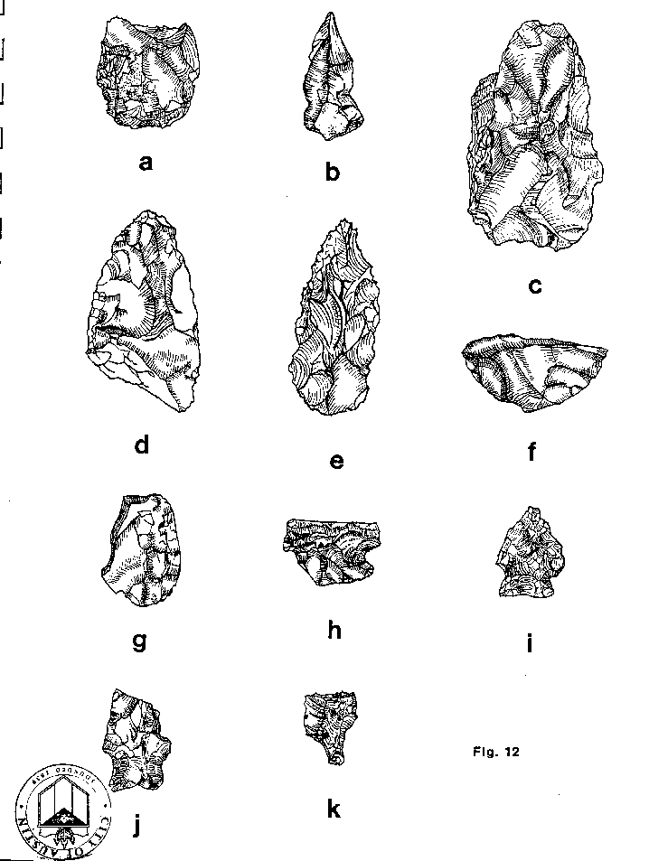
These are arrowheads found in the search area. Several other drawings and photos are included in the document and may be added later.
41TV370
A re-examination of this site revealed more extensive cultural deposits than had been observed during the initial survey. The prehistoric material appears to cover the entire field between the Tar Branch and Walnut Creek. Prehistoric material collected from the surface includes a Tortugas point, a thick biface, a utilized flake, two distal tips, a thin biface fragment, and a fragment of what appears to be a corner tang knife. Other artifacts from the Ellison collection are described below. Along the Tar Branch a suspected hearth was observed eroding from the cut bank of the stream. The immediate area of the suspected feature was cleared away. All matrix was passed through 4" wire mesh. Vertical and horizontal measurements were taken from a temporary datum, a metal staple set in a nearby tree. A slightly disturbed oval shaped (50x63 cm) hearth was revealed (Fig. 15). The feature was bisected east to west then again north to south. All matrix was collected and water screened. No cultural material was recovered from the 4" screen or the fine screen. No charcoal was observed and no faunal remains were recovered. Of particular interest is the fact that several of the large limestone cobbles used in the hearth's construction and numerous small pebbles from the hearth matrix exhibited hydrocarbon remains (Ed Garner 1980: personal communication). At this time it is not known if the hydrocarbons were introduced by man or deposited by flooding of the Tar Branch which is reported to have had a tar seep deposit. In addition, informants report that a man named Ross lived on the site when J.E. Cearley arrived in the 1850's. His house is said to have been on the edge of the bluff above a spring on Walnut Creek (Ross' Spring) just to the east of where the power lines now cross Walnut Creek. An inspection of this-general area revealed a thin scatter of 19th Century artifacts including hand-blown green bottle glass, stoneware, blue transfer-printed ware and pink glass. The artifacts were collected from the field north of the reported location of the house. A few large limestone blocks appear on the edge of the bluff and down the slope. It is not known if these were construction stones.
Site 41TV370 appears to have deep soils in the northwest portion and also along the banks of the Tar Branch and Walnut Creek. In the central portion of the site, the surface is littered with chalk gravels and dense stands of cedars thrive in this area.
Page 55
Return to Copperfield History Page
Go to Copperfield Main Page

FastCounter by bCentral