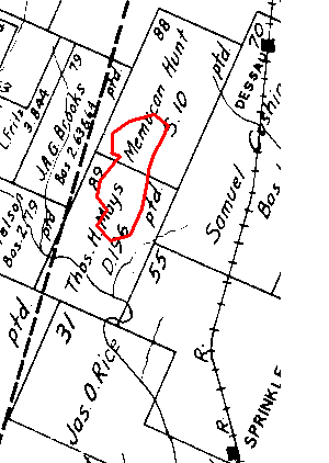
The dashed line is a surveyor's line. I35 today is a little to the left of the dashed line.
Yager Lane today is, I believe, on or a little to the south of, the dividing line between the properties of Memucan Hunt and Thomas H. Mays.
Braker Lane today is on the dividing line between the properties of Thomas H. Mays on the north side and the properties of John Applegait and James O. Rice on the south side.
Dessau Road today is on the dividing line between the properties of Memucan Hunt and Samuel Cushing.
The railroad line running through the property of Samuel Cushing is an old line, the Missouri, Kansas and Texas Railway (often referred to as the "Katy"), that was taken up decades ago. The remains of the railway bed can be seen off of Yager today between Dessau Road and the Samsung manufacturing facility. The recently proposed SH130 may use parts of this old railway bed.
The meandering line is Walnut Creek.
The map shows that the communities of Dessau and Sprinkle were once free-standing towns and were on the Katy railroad tracks.
Click here to see a wider property map of the north Austin area in 1936.